

First Nations Stories of Disaster Tell of Radical Environmental Change
First Nations Stories of Disaster Tell of Radical Environmental Change

Outside my window as I write, I gaze down at the Minas Basin, home to a First Nations legend. Long dismissed as a fantasy for the tribal elders to amuse their children with, it turns out to be a narrative about a strange phenomena that changed the environment in a flash.
First Nations stories of course describe events in a “pre-history” context - before the time when European chroniclers arrived who could record an official script. Their stories about environmental disaster are often dismissed as invented tales, but an increasing number of scholars are re-examining their accounts in search of eye-witness evidence of catastrophic environmental events. The First Nations, as it turns out, often provided real-world, credible evidence describing disastrous change in the world they once knew.
Their accounts and experiences tell us what could happen in our own world if an unimaginably large change happened in our surrounding environment.
There are many First Nations stories to pick from, and I will just describe four:
The Mount Mazama climactic (or caldera-forming) eruption, 6850 b.p. (‘before present’, the archeological measure of time before the year 1950, when radiocarbon dating was invented)
The Bonneville/Cascade landslide, 900-400 b.p
The megathrust earthquake-related tsunami, 300 b.p. and
The Minas Basin saltwater invasion, which I referenced earlier and which we can start with…
For context, the Minas Basin is an arrowhead-shaped inlet that runs from a narrow neck called Race Passage up a hundred kilometers (50 miles) to a shallow bridge of land that separates the Bay of Fundy from the Atlantic Ocean. Scampering along its beaches once were the smallest dinosaurs ever found, and early mammal-like reptiles. I get a kick out of knowing that this part of North America was once attached to Africa, and the beach that I stand on is the same sand that I once stood on in Africa facing West, where the Sahara meets the Atlantic.
The Minas Basin’s name comes from a translation of the French title given by Samuel de Champlain in 1604: Le Bassin des Mines, which means The Basin of Mines, referring to mineral deposits of silver, zinc and copper along the shore.
Interestingly, when Champlain’s men were walking along the shore, they found an old moss-covered Christian cross in the sand. Someone from Europe, perhaps centuries before, had been blown across the ocean and been shipwrecked here.
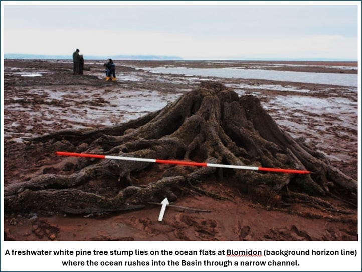
Along with the minerals, there are layers of peat deposits along the Basin, with the remains of tree trunks of white pines. Champlain may not have wondered about them, but they have puzzled generations of geographers.
Peat and white pines are freshwater plant remains.
The Minas Basin is a saltwater bay, open to the ocean.
Tilt?
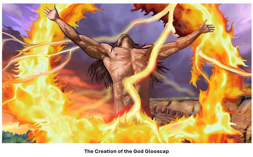
Here is the story from the Mi’kmaw First Nation, as revealed by geologist Elizabeth Kosters in the journal of the Blomidon Naturalists Society:
One day, the god Glooscap wanted to take a bath and asked Beaver to help him. Beaver happily agreed and build Glooscap a dam. Water pooled behind it, filling the Basin and creating an immense lake. After his bath, Glooscap asked Beaver to remove the dam so the tub could be emptied, but Beaver refused. Glooscap got angry and threw a few rocks a Beaver (which became the Five Islands) but Beaver still refused to take out his dam. Then Glooscap asked the whale to help him, and the whale flipped her tail, and the dam broke.
The Minas Basin was immediately transformed from a freshwater lake to a saltwater estuary.
The MikMak had lived here for 10,000 years before the freshwater lake flipped to become a saltwater tribute of the Atlantic Ocean. Some time around 4,400 years ago, they witnessed a catastrophic event that changed their way of life in a flash.
The freshwater ecosystem that nourished them suddenly became a tidal flood of seawater. It happened within one human lifetime.
It was caused by climate change (or by a whale, depending…)
A gradual rise in the level of the ocean due to melting ice caps led to the formation, along the Bay of Fundy, of a ‘standing wave’. It has the same properties as a tidal wave, but it is continuous. The tidal energy pushes it along at 300 km/hour. The wave jets into the neck of the tidal bore at Blomidon at a speed of 10 m/sec – so fast that no sediment can form on the bedrock.
The gravel barrier that separated the lake from the ocean was suddenly swept away, and fresh became salt.
Overnight, the middens – shell mounds – of the MikMak changed from fresh water to saltwater species. A new way of life had been invented.
To this day, the ocean current that floods through the passage carries more water with each tidal change than that which flows in all of the rivers on Earth, put together.
It surges up the Basin and creates the world’s highest tides, right on my doorstep. The world record tidal change of almost 55 feet occurs at Burntcoat Head, on the southern shore of the Basin. When you walk along the beach at low tide, you are conscious that you are walking fifty feet below the point where the dorsal fin of a great white shark will be moving twelve hours later.
But it’s all good…if you keep walking and it keeps swimming, you’ll never meet.
Efforts to tap that energy surge for tidal power keep getting washed out to sea. Too much of a good thing.
Something else that’s “too much of a good thing”, is the power of the wind around cliffs. Cape Blomidon got its name from the old English sailors’ phrase “Blow Me Down” - something that used to happen to the old wooden sailing boats when the air currents suddenly shifted. The “gales of August” were an especially bad time, when whole fleets of fishing boats would be crushed in the wind, and the women would gather along the shores to bring in the remains of their husbands, sons and brothers.
Those winds came from Africa, starting as a gentle breeze over the water…as if the old country was calling out to Nova Scotia: “how are you? We miss you…” And as it traverses the Atlantic, it picks up energy and power and by the time it reaches our shores it is the August scream that is so deadly.
The guy down the road from me is the head of the provincial wind power organization and his windmill was blown away. That’s how bad it gets.
Glooscap is said to live on the cliffs overlooking my house, keeping an eye on the remains of his bathtub and watching the effort to tame his Basin with good humor.
And if you were a First Nation chronicler and you had to explain the suddenness of the change in the water and in life, a story about a god, a beaver and a whale makes everything immediate and comprehensible.
From the Atlantic we can move across the continent to a cluster of volcanoes on the West Coast that was destroyed during an enormous explosive eruption 7,700 years ago. So much molten rock was expelled that the summit area collapsed during the eruption to form a large volcanic depression, or caldera. Subsequent smaller eruptions occurred as water began to fill the caldera to eventually form the deepest lake in the United States.
A towering column of pumice and ash reached into the sky some 30 miles. Winds carried the ash across much of the Pacific Northwest and parts of southern Canada. So much magma erupted that the volcano began to collapse in on itself. As the summit collapsed, circular cracks opened up around the peak. More magma erupted through these cracks to race down the slopes as pyroclastic flows. Deposits from these flows partially filled the valleys around Mount Mazama with up to 300 feet (100 m) of pumice and ash. As more magma was erupted, the collapse progressed until the dust settled to reveal a volcanic depression, called a caldera, 5 miles in diameter.

The explosion at Mount Mazama followed a series of smaller events and significantly altered the immediate surrounding landscape. Chambers of lava ate the mountains and caused a sudden collapse. Pyroclastic flows – super-fast, super-hot gas eruptions - devastated the surrounding area, including all of the river valleys that drained the area. The ash-fall extended northeast of the volcano as far as Saskatchewan, Canada. It was one of only four eruptions in the past 10,000 years that could be called “supercolossal”.
There were witnesses to this terror.
Archaeological finds in central and south-central Oregon indicate the presence of humans in that area prior to the Mount Mazama climactic eruption.
They must have been thinking: I walked across the land bridge from Asia for THIS?
They interpreted the event as a punishment that the Chief of the Below World inflicted on the tribes because they hid a maiden from him “When the messenger returned to the middle of the mountain and reported the maiden’s answer, the Chief of the Below World was very angry. In a voice like thunder, he swore that he would have revenge on the people of Loha, that he would destroy them with the Curse of Fire. Raging and thundering, he rushed up through the opening and stood upon the top of his mountain. Then he saw the face of the Chief of the Above World shining among the stars that surround his home. Slowly the mighty form of that chief descended from the sky and stood on the top of Mount Shasta. From their mountaintops the two spirit chiefs began a furious battle. In a short time all the spirits of earth and sky took part in the battle.
“Mountains shook and crumbled. Red-hot rocks as large as the hills hurtled through the skies. Burning ashes fell like rain. The Chief of the Below World spewed fire from his mouth. Like an ocean of flame it devoured the forests on the mountains and in the valleys. On and on the Curse of fire swept until it reached the homes of the people. Fleeing in terror before it, the people found refuge in the waters of Klamath Lake. Mothers stood there holding their babies in their arms and praying that the awful war might end.”
Overnight, the top of the mountain fell and a great hole was created, that filled with rainwater.
The First Nation account accurately described three phases of the event: the set-up, consisting of a mountain without a lake; the event itself with a boil-over of lava; and the post-event adaptation period when a lake formed.
Natives were present for the event, and lived through it as generations adapted to a new environment. However, to this day, there is no physical feature that so completely overcomes the ordinary First Nation inhabitant with fear as Crater lake. They remember.
Another catastrophic paleoenvironmental event in the region of the Oregon and Washington states that is represented in native oral traditions is the Bonneville or Cascade landslide that happened around 1100 AD. The Columbia River gorge suffered a landslide that blocked up 21 cubic kms of water, forming a lake that might have extended 150 km long. Periodically the dam would break, and waves up to 20 metres tall would crash down the gorge, flooding what is now Portland. People were certainly directly affected, if not killed.
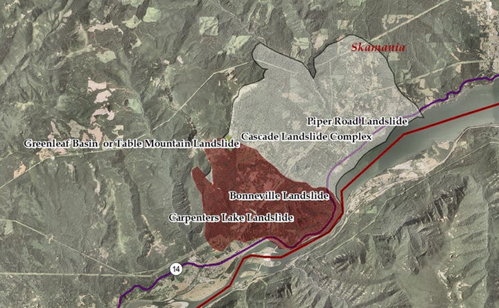
A traveller in 1905 recorded the First Nations narrative: “Our grand-fathers remember the time when the waters passed here quietly and without obstruction, under a long range of towering and projecting rocks, which, unable to bear their weight any longer, crumbled down, thus stopping up and raising the bed of the river; then it overflowed the great forests of cedar and pine, which are still to be seen above the Cascades.”
To this day, the traveler can be astonished by the great number of huge tree trunks, still standing upright in water about twenty feet deep.
They did not invent the story to explain the reason for the tree trunks in the water; they saw it happen and passed the story down by word-of-mouth.
Another account describes a tsunami – a tidal wave – that hit the Western shores around 1700 AD, just before Europeans came. The West Coast is a zone that is infamous for the movements of its tectonic plates; as they shift past each other, tremendous tension forms in the rock and is often discharged by a sudden earthquake. Megathrust earthquakes are also the most catastrophic type that can occur.
Evidence from First Nations sites, such as drowned vegetation, waterlogged twined matting and various other cultural remnants, all indicate that the most recent subsidence within the Cascadia zone occurred 300 years ago.
When the tidal wave hit “a noise like the report of a great cannon was heard and the river began to rise rapidly. There was no rain at all. As the water rose they pulled on the rope tying down their raft and rose with it till the top of the mountain was reached. Then the waters slackened. When the flood had subsided and let their raft down, again it was found that all the animals had been drowned and the fish had died; there was nothing for the people to eat but the bodies of the drowned animals or the floating fish. A great number of those saved from the flood now died from a sickness caused by eating the dead flesh… The people that walked all died. Those that had canoes and water and food lived.”
They recorded that complete villages were buried, and that people who had lived inland now found themselves on a coast.
They accurately described a terrifying event, in which the land shook for days, then the water receded and came rushing back at enormous speed. The shaking and flooding kept going for days. Afterwards, many took the precaution of residing on mountaintops; others dispersed and their nations spread.
In the early 1980s, the US Nuclear Regulatory Commission (NRC) was considering whether to locate nuclear power plants in Washington and Oregon, and, just to be sure, asked the US Geological Survey (USGS) whether the Cascadia Subduction Zone was safe from earthquakes. A young researcher suggested that the area has not been hit by earthquakes because the locking of the plates had not yet released their energy. He took the trouble to ask the Malah people in Washington if they had any stories or legends.
One Makah story in particular resembled the 1700 tsunami. “A long time ago but not at a very remote period,” the story began, the ocean receded quickly, then rose again until it submerged Cape Flattery; canoes were stranded in trees and many people died.
The researchers did something un-geoscientific: they decided to take the Makah story not as myth, but as history. That is, they assumed the Makah were describing a geologically-recent tsunami.
Then they found other stories, most of them undatable, that were probably about other, even earlier earthquakes. The two scientists systematically plotted these coastal stories on a map of the archaeological and geological evidence of all Cascadian earthquakes and tsunamis.
The Cowichan people on Vancouver Island, the Squamish in southern British Columbia, and the Makah in Washington each had stories about the earth shaking so violently that no one could stand, or the houses falling apart, or rockslides coming out of the mountains and burying villages. The Nuu-chah-nulth, like the Makah, told stories of the ocean receding suddenly, then flooding back powerfully and killing many, many people.
These were reasonable records of real events. So much destruction repeated for so long had a terrific impact on the indigenous groups’ worlds.
First Nations people were and are intimately familiar with their environment. Drastic changes in that environment had profound impacts on them, even perhaps altering their collective mindset.
Robert Dennis, Chief Councillor of the Huu-ay-aht First Nation in British Columbia, had also heard stories. When he was 11 or 12 years old, he used to visit his great-grandfather, who’d been chief of the Huu-ay-aht for decades. “He’d say, ‘I’m going to tell you things that might be important in your life, and this could happen again.’” One of his stories was about his great-grandfather who lived at Pachena Bay, on the west coast of Vancouver Island. One night the land shook, and a big wave smashed into the beach, and the people who lived on the bay were all killed. But the people who lived on high ground, the water couldn’t reach them, and they came out of the tsunami alive. Dennis thought his great-grandfather told him this story so Dennis could someday tell the story himself and because he also would be a leader responsible for his people. So years later when the Huu-ay-aht were planning a community center, they first consulted their elders, then they built the center not down in the flats but up on high ground. Now they have to stock it with food and emergency gear and keep it stocked. “I’m not going to rest,” says Dennis. “I’m going to keep pushing it. So we’re ready.”
The ground moves and doesn’t stop moving, and almost no one survives the tsunami. So get off the beach. Go up into the hills.
Be prepared - something that the European colonists did not do. They had no stories.
Preparation can mean everything. The 2004 Indian Ocean earthquake that killed 200,000 people in the Indonesian province of Aceh, killed only seven of the 78,000 people living on the island of Simeulue because the Simeulueans had been telling stories for generations of what to do during tsunamis.
In today’s age of climate-induced change, it would be wise to go back and research these First Nations stories. They might prepare us better for survival in an apocalyptic world.
Our changes have happened before. They were recorded by the cultures of First Nations people living in our land.
If we want to survive, as they did, we should listen to them more seriously.
They knew what they were talking about…first-hand knowledge from the First Nations people.
It could save many lives, and make our return from catastrophe a more certain endeavor.
It would also, of course, be a sign of respect to those who underwent so much, before us.
In many ways, we are more vulnerable than they ever were.
They at least could live off the land, in almost any circumstance.
Our cultures today are a bit more…fragile. As soon as the electric power goes down, the doomsday clock starts.
I keep looking up at those cliffs, and wondering about Glooscap.
The power his people saw, racing through the channel, is still coiled up and waiting for us.
The environmental news keeps getting worse, so the turn-over in the known world is not going away.
I recommend you read a few of the First Nations legends, with a view to your own survival in mind.
Then move to the high ground…
To everyone, thank you for reading Barry’s Substack - a community of commentators on the meaning behind the headlines.
Please support our work by becoming a paid subscriber; your comments and thoughts could be included in future articles.

One of your best ever, Barry. I should qualify that. One of your best since I first stumbled into you. [A year, maybe? Working on the subscription thing btw. Living on SS, so I need to juggle a few things first.]
All that said, how you manage to research so much, let along translate it into a coherent [and fun] essay for the rest of us, never ceases to amaze me, This one? I rest my case.
And, if anyone has ever validated Kur Vonnegut the way this one does, I would like to see it. Pretty sure that it doesn’t exist.
“1492. As children we were taught to memorize this year with pride and joy as the year people began living full and imaginative lives on the continent of North America. Actually, people had been living full and imaginative lives on the continent of North America for thousands of years before that. 1492 was simply the year sea pirates began to rob, cheat, and kill them.” - Kurt Vonnegut Jr.
Please, don't ever stop.
Pete